
Day 2: Coal in Pennsylvania Map Activity
Lesson Plan - Discussion of the Distribution of Coal in PA
Developed by 2008-2009 TESSE Graduate Fellows from Penn State University (http://sites.psu.edu/drlauraguertin/)
Objectives
Students will:
- Use a map to determine which ranks of coal are present in PA as well as how coal resources are distributed throughout the state.
- Utilize the their newly gained knowledge on coalification as well as shaded relief and physiographic province maps of PA to come to an understanding of the impact of mountain building on coalification and to explain how it controls the geographic distribution of bituminous and anthracite coal in the state.
- Review key geologic and geographic concepts such as latitude and longitude, mountain building, and geologic time, as well as locate mountainous regions of PA (Appalachian and Allegheny Mountains)
Materials
- Distribution of Coal in PA Map and Transparency
- Transparency Markers
- PA digital shaded relief map
- PA physiographic province map
- Coal in PA worksheet
- Coal in PA Power Point
- Animation or figures showing collision of Africa and North America leading to the formation of the Appalachians
- Photos showing bituminous coal seams in western PA and anthracite coal seams in folded rock layers in eastern PA
Files
| File Name | Type and Size |
|---|---|
| Coal in PA - Lesson Plan | MS Word - 653 KB |
| Worksheet for Coal in PA - Worksheet | MS Word - 6.2 MB |
| Coal in PA Presentation | MS PowerPoint - 5.6 MB |
| File Name | Preview / Type and Size |
|---|---|
| View image of the Distribution of Pennsylvania Coals | 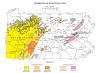 JPG - 190 KB JPG - 190 KB |
| View image of a Digital shaded-relief map of Pennsylvania | 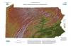 JPG - 6.1 MB JPG - 6.1 MB |
| View image of the Physiographic provinces of Pennsylvania | 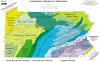 JPG - 240 KB JPG - 240 KB |
List of Resources
- Blakey, R. (2010), Appalachian Mountain Formation Paleomaps
- Coal Field Photo and Geologic Record Comparison (2008)
- Coal Field Photo by Cornell University
- Edmunds, William E. (2002), Coal in Pennsylvania (Distribution of Coals in PA Map and Coal Seam Illustrations), Harrisburg: Pennsylvania Geologic Survey Fourth Series
- PA Physiographic Province Map from PA Department of Conservation and Natural Resources (2000)
- PA Digital Shaded Relief Map from PA Department of Conservation and Natural Resources (1999)
- The Paleontology Portal