
Teaching About Volcanoes in a Plate Tectonic Context
Activity Description
Note: This is not an activity but rather background information on types of volcanoes. It can be modified.
See Also - Hawaii and Indonesia – Activity and Information for Students
Background
Volcanoes are a natural draw for students to engage in Earth Science because they are beautiful, dangerous and exciting. They also provide important windows into the planetary interior: as part of the overall dynamic operation of the planet they are critical to our understanding of plate motions and the convective circulation of the Earth’s interior. Middle grades instruction about volcanoes typically focuses on student mastery of lower-order skills (recollection, definition) rather than on higher-order approaches (synthesis, integration). This situation is unfortunate, because the rich context for volcanism and volcanoes present an ideal opportunity for integrating several areas of Earth science that are challenging to students: three-dimensional visualization, working with extremely long time scales, and scientifically complex processes and vocabularies.
This learning unit is designed to help students understand the differences between volcanoes that result from two different sets of dynamic forces: hot spots or mantle plumes, represented in this unit by Hawai’i, and convergent plate settings, represented here by Merapi, Indonesia. The volcanoes have distinctly different morphologies that reflect the composition and viscosity of the magmas involved in each setting. They also show distinct age progressions that highlight the differences in tectonic setting. Both volcanoes are extremely active and long-lived, so students and teachers can augment the materials here through independent or guided inquiry. By integrating this range of information students can build a comprehensive and mechanistically self-consistent model of volcano formation that reinforces the challenging concepts of plate tectonics. The activities described here also lend themselves to partnering with teachers in other areas such as geography, mathematics, language, literature and biology.
When we think about volcanoes, it’s common to picture giant mountains that spew red hot lava straight out the top. Think “elementary science fair” (vinegar and baking soda combined inside a volcano shaped from clay) or movies like Volcano and Dante’s Peak where actors sprint down the mountain side trying to escape the lava flow. But do all volcanoes really behave like this? There are hundreds of active volcanoes around the world today. Unlike dormant or extinct volcanoes, active volcanoes either are currently erupting or are expected to erupt in the near future. Kilauea of the Hawaiian-Emperor Volcanic Chain and Mount Merapi of Central Java are both active volcanoes. In this activity we explore where these volcanoes are located with reference to the boundaries of the lithospheric plates, as well as their appearances, eruptive styles and products. By taking a closer look at these examples we can start to see that not all volcanoes are identical. In fact, there are many characteristics of volcanoes that not only make them distinguishable from each other, but that we can use to understand the paradigm of plate tectonics and the forces that shape the surface and interior of our planet.
We will also address several misconceptions that students bring to the study of volcanoes and their relationship to plate tectonics. The ideas below reflect many conversations with students and teachers on this topic.
Misconception 1: There is no connection between Pangaea and the paradigm of plate tectonics.
Comments: Many students are aware of the theory of continental drift, and can recognize an image of Pangaea. However, the assembly and disassembly of Pangaea is not always seen as the result of plate motions. We note further that students do not always associate volcanism with both convergent and divergent plate motions, nor do they distinguish plate boundary volcanism from that related to deep mantle plumes or hot spots.
Misconception 2: Adjacent volcanoes (such as those in Indonesia) cannot be the same age.
Comments: Many students are aware of the Hawaiian Islands and have some familiarity with the age progression that is recorded by this sort of hot spot volcanism. In contrast, it is uncommon for students to understand that volcanoes which form in subduction zones are all the same age. It is likely that considerations of geologic time contribute to this misunderstanding, because a chain of contemporaneous volcanoes (such as the Andes or Cascades) tend not to erupt all at the same time as viewed from the perspective of human lifetimes. Adjacent volcanoes that erupt several hundred years apart are still considered to be active concurrently.
Misconception 3: Oceanic currents are related to plate tectonics or volcanism.
Comments: Most students attribute the difference between ocean crust and continental crust to the presence of water. As we see on the moon, however, crustal thickness is controlled by the type of rocks that have formed, and water plays at most a subordinate role in the generation of subduction-related volcanoes. An additional complication for students may be that any familiarity with volcanoes often centers of islands such as Hawai’i, further reinforcing the idea that water plays a role. This misconception is often very deeply held and difficult to overcome.
Misconception 4: Volcanic features (age, shape, rock type, eruptive style) are not related to the tectonic setting where volcanoes are formed.
Comments: Volcanoes have characteristic lava chemistries, eruptive styles, edifice morphologies and life spans that reflect the tectonic environment in which they form. There are three primary settings for volcanism: mid-ocean ridge divergent plate margins, subduction zone convergent margins, and hot spots which may be located on either continental or oceanic crust. Each of these settings is readily identified by the volcanic products and their styles of emplacement. This misconception can be addressed by teaching about volcanoes in a holistic manner, in which the individual features are related explicitly to the tectonic setting.
Introduction to Hawaii and Indonesia
Tectonic Setting
In which tectonic settings are these volcanoes found? Take a look at the map of the active volcanoes and their locations relative to plate boundaries. Are volcanoes usually found along plate boundaries or far away from them? Find Hawaii (H) and Indonesia (I) on the map. Using GoogleEarth, we can pinpoint the exact location of both Merapi and the Hawaiian volcanoes and take a “fly-in tour” of both volcanoes - see the Volcano Tour files at the bottom of the page.
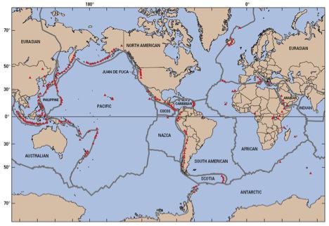
Figure 1. Map of major lithospheric plates, with red triangles indicating active volcanoes. USGS
You can see from the map above that Merapi and the other Indonesian volcanoes occur at a plate boundary, specifically the convergent boundary where the Indian Ocean Plate collides with and is forced beneath the Asian Plate, in the process known as subduction. Merapi is part of the Sunda Arc, which stretches for over 3000 km as a curved line of active volcanoes along the plate boundary. Subduction boundaries may involve two oceanic plates or an oceanic plate and a continental one. When the dense oceanic plate is forced downward, under the much lighter continental or slightly lighter oceanic plate, magma produced in the shallow mantle rises to form crustal magma chambers that feed the individual volcanoes. The Ring of Fire is perhaps the most famous region of subduction. This area is marked by numerous active volcanoes around the rim of the Pacific Ocean.
Indonesia consists of more than 13,000 islands, spread over an area approximating that of the conterminous United States. The disastrous Krakatau (Krakatoa) eruption of 1883 is the largest recorded eruption in human history. Indonesia has the largest number of historically active volcanoes (76), and a total of 1,171 dated eruptions. Four-fifths of Indonesian volcanoes with dated eruptions have erupted in this century. Indonesia has suffered the highest numbers of eruptions producing fatalities, damage to arable land, mudflows, tsunamis, lava domes and pyroclastic flows. Most of the Merapi volcanic products are basaltic andesites and dacites, and the eruptions are moderately to highly explosive. Merapi has been active repeatedly in the past decade, and has erupted regularly since 1548. It is located 28 km north of Yogyakarta city, which continues to be threatened by ash, lava and pyroclastic flows.
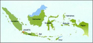
Figure 2. Map of Indonesia, showing location of Mount Merapi (yellow star). TIN
Hawai’i is not located near a plate boundary. It actually is located in the middle of the Pacific Plate. The Hawaiian volcanoes did not form from subduction or any other plate boundary processes. These volcanoes are evidence for hot spots, thin columns of unusually warm mantle that rise from great depth independent of the convective circulation that drives plate motions at the surface. Plume-derived magma breaks through the crust and gradually supplies lava that builds a volcano. As the lithospheric plates continue to move slowly, the hot spot will form many individual volcanoes adjacent to one another. With time, the volcanoes keep drifting westward and getting older relative to the one active volcano that is over the hot spot. As they age, the crust upon which they sit cools and subsides. This phenomenon, combined with erosion of the islands once active volcanism stops, leads to a shrinking of the islands with age and their eventual submergence below the ocean surface.
The Hawaiian volcanoes were produced by the Hawaiian hot spot, which is presently under the Big Island of Hawai’i. Each island is made up of at least one primary volcano, although many islands are composites of more than one. The Big Island, for example, is made of 5 major volcanoes: Kilauea, Mauna Loa, Mauna Kea, Hualalai and Kohala. Mauna Loa is not only the largest active volcano on Earth, but also the largest mountain in the world, rising over 30,000 feet above the ocean floor and reaching almost 100 miles across at its base. Kilauea is presently one of the most productive volcanoes on Earth (in terms of how much lava it erupts each year). The primary volcanoes on each of the islands are shield volcanoes, gently sloping mountains produced from a large number of generally very fluid basalt lava flows.

Figure 3. The Hawaiian-Emperor chain is located in the central region of the Pacific Plate. USGS
Volcano Features: Morphology, Lava Composition, Viscosity and Gas Content
Now that we understand better how these two different types of volcanoes have formed, we can examine other features that are related to the distinct tectonic settings. Take another look at the fly-by tours and consider the different shapes of the volcanoes themselves. Kilauea in Hawaii is a very broad shield volcano with a small crater at the top and a shallow, sloping profile. Merapi is a steep-sided stratovolcano that dominates the landscape (the white material is recent ash, not snow). It does not have a crater at the top today, but one day a major eruption will create a crater that could be tens of kilometers in diameter.
The different volcano morphologies are created by the types of lavas that form in subduction and oceanic hot spot environments. These two settings are characterized by lavas with different chemical compositions, leading to very different viscosity and explosivity, factors which control the overall shape of the volcano. Viscosity is the term used to describe a fluid’s resistance to flow. The higher the viscosity, the thicker or less runny the lava is when it flows. Honey and toothpaste are both highly viscous fluids, whereas water and vinegar have low viscosities and flow very quickly and easily. Which volcano do you think was built from more viscous lava – Merapi or Hawaii? In Hawaii, where the oceanic crust is thin, basalt magma rises easily from the mantle and erupts in large, low-viscosity flows that cover the landscape. In Merapi, where the crust is thicker, basalt magma usually does not erupt directly but instead forms large chambers in the crust where the magma’s chemistry changes slowly to produce andesite, dacite and even rhyolite. These materials can be quite highly viscous, and their eruptions often produce small sticky lava flows that adhere to steep volcano slopes. The resulting stratovolcano shape is very characteristic of subduction or arc environments, including the Andes and Cascades.
Another difference between these two types of volcanoes is the amount of gas contained in the lava. Differences in gas content – like other types of lava chemistry – reflect the tectonic setting of the volcano. Do you think an eruption would be more explosive with a little or a lot of gas? During subduction, water that is trapped in ocean floor sediments gets pulled into the mantle. When this material heats up, the water catalyzes mantle melting and becomes incorporated in the resulting melt. As the magma evolves towards viscous compositions the water may vaporize, leading to explosive eruptions that eject massive amounts of ash, debris or pyroclasts (literally, fire pieces). This eruptive style is characteristic of Merapi and all subduction-related volcanoes. The Hawaiian lavas have less gas and lower viscosity, and as a result these eruptions are not as violent as those from Merapi. The less violent environment attracts tourists and people who visit can often approach the lava flows with only limited danger (but still must remain cautious).
Use the “Build Your Own Volcano” website simulation to see if you can set the conditions correctly to form a volcano like those in Hawaii and Indonesia. http://discoverykids.com/games/volcano-explorer/
Prepared by: Tanya Furman & Molly Witter, Department of Geosciences, Pennsylvania State University, 2011
| Attachment | Size |
|---|---|
| 6.04 KB | |
| 6.6 KB |