
Exploring Regional Climate Patterns and Generalizing the Results to Enhance Deep Conceptualization
Standards Addressed
3.3 A5 for grades 6-8.
3.3 A6 for grades 6-8
3.3 A7 for grades 6-8
Preparation Time Needed
Prep time needed will be dependent on the teacher for them to become familiar with the exercise themselves. Otherwise, all materials are there and available and don’t need any physical preparation. I’d maybe say 5-10 minutes for the teacher to make copies of the alien planet map and the ocean current map.
Class Time Required
This article describes a 1-2 week unit on the factors influencing regional climate, focusing on student abilities to describe data, generalize the trends they see, and make predictions justified by their data.
Activity Description
An understanding of climate science and the processes that control Earth’s past, present and future climate is increasingly important for students both as potential scientists and as future decision-makers in our society. Before students can begin grappling with the concept of anthropogenic climate change, they must build the necessary vocabulary and background knowledge for participating in meaningful discussion about the natural climate system. This article describes a 1-2 week unit on the factors influencing regional climate, focusing on student abilities to describe data, generalize the trends they see, and make predictions justified by their data.
Unit Components and Implementation
Introduction
While this unit could creatively be positioned in many ways within the curriculum, in the author’s classroom it is nested between units on energy resources and climate change, serving as the transition between the two. The first day following completion of the energy resource unit begins with a brief discussion of climate and climate change, eliciting what the students already know or think about the two terms, and concludes in a class brainstorm of the questions that need to be answered in order to begin to understand climate change. Inevitably some variation of these questions arises: “What causes/affects climate?” and “Why is climate different in different places?” These are questions that the students can recognize as being essential to their ability to understand and discuss climate change, and the investigations begin.
In order to discuss the phenomena that cause climate to vary geographically, it is necessary to adopt a classification system. Without a mechanism of generalizing the regional climate characteristics on a global scale, students easily become overwhelmed and unable to investigate in a consistent manner the factors that lead to these variations. For simplicity the organization included in the Pearson Prentice Hall textbook Science Explorer: Weather and Climate was used (Brooks Simons, 2007). This system classifies Earth’s climates into 5 regions (Tropical Rainy, Dry, Temperate Marine, Temperate Continental, Polar) that are subdivided into a total of 12 climates, including one specific to mountain elevations that does not belong to any of the 5 larger regions.
Step 1: Noticing Trends in Air and Ocean Circulation
The first step in investigating the complexities of climate comes in trying to understand the fluid dynamics of atmospheric circulation. Prevailing winds play a major role in regional climate, and are caused by interaction between the large, latitude-based convection cells and the Coriolis Effect that results from Earth’s rotation. An understanding of the generation and structure of the Hadley, Ferrel and Polar Cells is essential background to Earth’s overall climate system, and is particularly relevant to predicting the existence and direction of prevailing winds. The students must be able to refer to this information in order to build their explanations later in the unit. While there are inquiry-based options available for both of these topics, for this unit they are taught through direct instruction to establish common ground among the students and to reserve their creative energy for the subsequent activity.
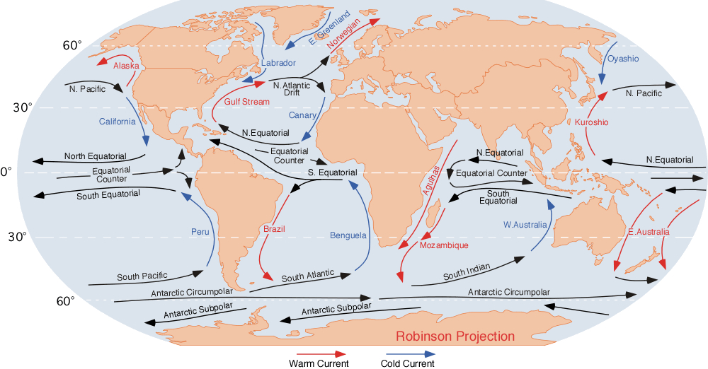
Once the students are familiar with the Coriolis Effect, they are given a world map displaying ocean currents (Figure #1 attached) and asked to explain both the pattern of currents and the reason why some currents are warm and others are cold. This task is completed as a brief writing assignment where the students are prompted to make claims that address two specific questions: (1) Why do ocean currents flow the directions that they do? and (2) Why is an individual current either warm or cold? They must support each of the two claims with reference to actual currents on the map and provide a scientific explanation for what makes their claim valid (emphasizing the CER framework). The goal of this task is for students to recognize the generally clockwise rotation in the northern hemisphere, the generally counterclockwise rotation in the southern hemisphere, and the movement of warm currents away from the equator and the cold currents away from the poles.
Latitude, altitude, geography and proximity of large bodies of water all impact regional climates and recognizing these effects will contribute to student understanding of climate in general. There are various ways of addressing each of these, and in this curriculum these factors have generally been taught through a mix of discussion and demonstration. Latitude is classically demonstrated by shining the beam from a flashlight directly onto a board and tracing the outline of the light, and then shining the light from the same distance but at an angle to demonstrate that the same amount of light is spread out over a greater area when the sun is at lower angles, which leads both to cooler weather at greater latitudes as well as the variation between seasons as that angle changes.
Students investigate altitude and geography directly, as they document the locations of deserts in relation to mountain ranges and the existence of highland climate regions. The significant effect of proximity to large bodies of water can be shown using heat capacity lab exercises or demonstrations (See “A Day at the Beach”). A second effective method is to show a weather map that represents graphically the temperature buffering effects of proximity to water.
Step 2. Noticing Features that Define Climate Regions
The significant learning in this unit comes as students are asked to create generalizations from a diverse suite of data and then apply those generalizations in a new context. Students are asked (either in pairs or in small groups) to list the 12 types of climate as listed in the textbook (Brooks Simons, 2007) and describe where they generally occur. They are given the following instruction:
List the 12 types of climate and describe where each tends to occur. This can mean various things, but generally speaking you should address whether each climate:
- Tends to be on just one side of a continent
- Tends to be next to or away from water/oceans
- Is influenced by warm or cold ocean currents
- Is influenced by an interaction between geography and the prevailing winds
- Tend to only exist at certain latitudes
- Tend to occur only within certain elevations
The students typically converge around 3-5 location characteristics for each type of climate. Given the previous instruction in the unit, students have traditionally been very successful in forming these generalizations through discussion with their partners or in their groups. When students struggle, the Mediterranean may be used as an example to work through as a class. This type of climate has very specific criteria: it occurs between 30 and 40 degrees north or south latitude and on the west coast of land masses at those latitudes. Students may at this point also begin looking for the factors (cool ocean currents, prevailing winds moving over land from the ocean) that produce the regional climatic features, but they are not asked to furnish that information until the application and justification section.
Application and Justification
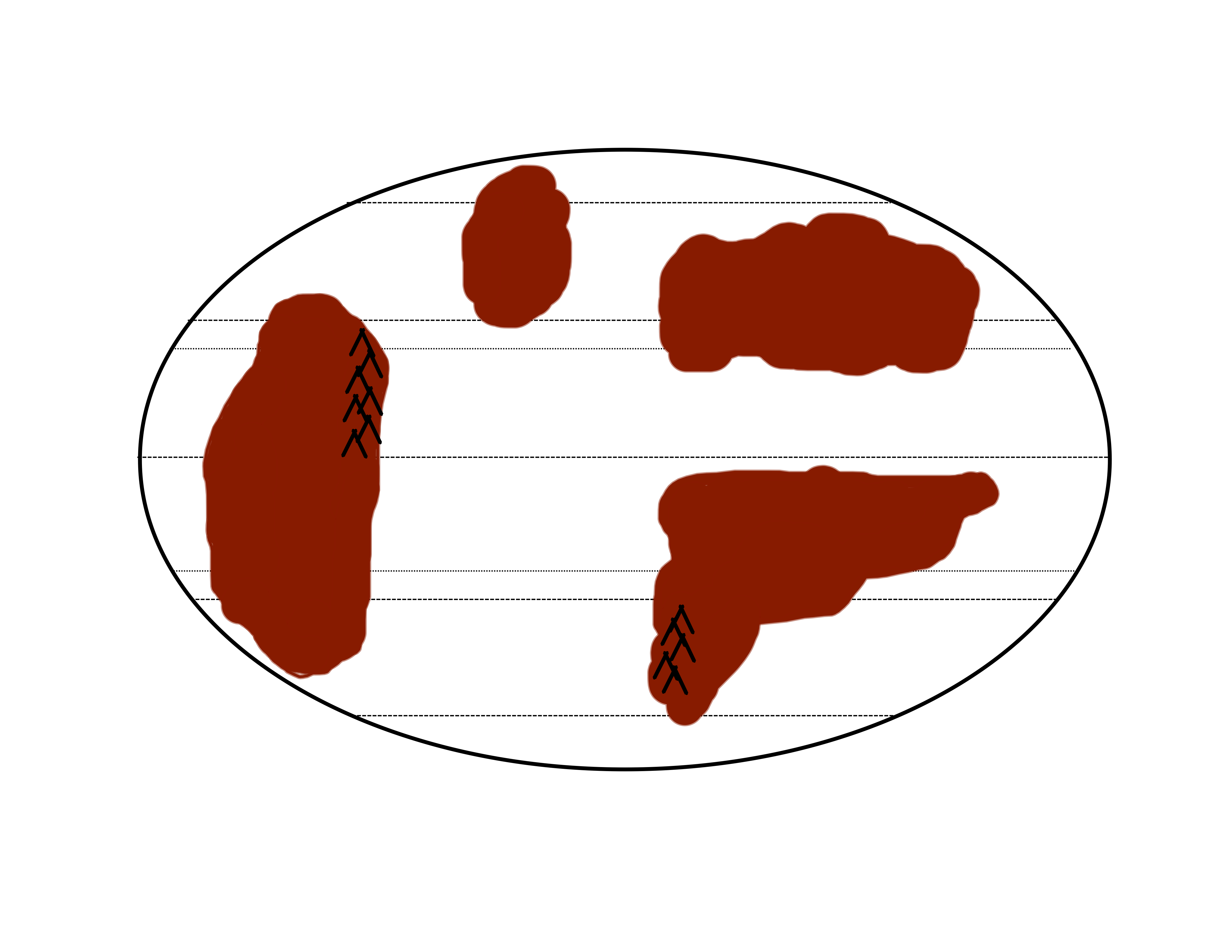
Once the students have a set of criteria of their own making for determining the climate region that would appear in any given geographic location, they are given a hypothetical planet with a different distribution of landmasses (see figure 2 attached below). The students are informed that the atmospheric and oceanic circulation processes on Earth work the same way on this planet and therefore the only difference is the location of the continents. As a class, students decide on names for notable geographic features (continents, oceans, mountain ranges) in order to facilitate discussion of climates on the alien planet. They are then asked to apply their knowledge of prevailing winds and ocean currents to mark those winds, warm currents, and cold currents that would likely form on this planet. An alternative approach to developing a hypothetical arrangement of continental masses is to employ paleogeographic plate tectonic reconstructions (http://www.scotese.com/) that may have particular significance for a specific region or time period.
Once all of the winds and currents are indicated, and the geographic features are named, students must identify one location on this planet for each of the twelve climate regions. This selection must be based upon the generalizations about each region that they had derived earlier. They must also justify the choice of each climate region in one or two sentences to explain their reasoning. Working in groups, students complete the map, while the reasoning statements are done independently after the map is completed. This step ensures that each member participates and develops an understanding of the material.
Grading
The map and the documents containing the geographic justifications serve as the final assessment for this short unit. The author works through the process along with the students as a demonstration every year. This joint effort creates an ‘answer key’ in hand once the maps are submitted, but because there is no unique solution this map is not the sole criterion on which the assignment is graded. The grade comes principally from the justification provided for each region. If a group’s submission for any given region does not match the teacher’s conception of this alien planet, but the members of the group provide a solid justification based on the evidence on the Earth’s climate map, they will receive full credit. On the other hand, if a student’s reasoning is poor but the region is located in the same place as on the teacher map, that student receives only partial credit. The following examples illustrate this grading system:
Example full-credit (3 pt.) explanation: Located on the east coast of Katniss is the humid subtropical climate region. This region experiences hot summers and cool winters. This climate region is influenced by the warm ocean currents which cause the temperature in the summer to get hot and the temperature in the winter to stay mild.
Note the description in the above example of how the warm ocean currents influence the nearby land. This is the type of reasoning that leads to full credit being awarded.
Example partial-credit (2 pt.) explanation: The wet humid subtropical climate is found from 20-40º, and typically above the tropics. It is on the southeastern coast of Brightville, and the middle eastern coast of Harperstan. This climate is found on east coasts, adjacent to warm currents. Prevailing winds do not affect this climate.
This explanation lacks a description of the role of warm currents, saying only that they are adjacent. The location given for the climate is reasonable, as are the trends, but adequate reasoning is lacking.
Example low-credit (1 pt.) explanation: The humid continental region was located on the Northeastern coast of Jeffathotmaildotcom near the Donkey Teeth Mountains. It gets high temperatures of 10ºC and -3ºC and lower in the winter. It is humid in the summer and cold in the winter.
This example gives a location for the climate, but provides no justification or explanation whatsoever. Even though the location is reasonable, only 1 point is given for this response.
Example no-credit (0 pt.) explanation: West side of continent and northern side of continent. Hot summers cold winters near equator and is near cold ocean currents. Located on Normanland.
The above description earns no credit, as it includes incorrect information and lacks explanation. In addition, the poor writing quality renders this answer unacceptable for credit.
| Attachment | Size |
|---|---|
| 454.17 KB | |
| 1.04 MB |